")

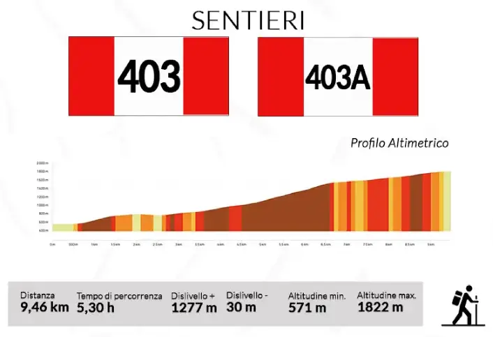
Il tracciato numero 403 è uno dei principali punti di accesso al Sentiero delle Acque e della Castagna. Si può percorrere da entrambe le frazioni ovvero sia da Canistro inferiore, attraverso la sua appendice – 403A - che dal borgo storico di Canistro superiore.
Il sentiero consente non solo di percorrere il circuito ad anello ma anche di raggiungere una delle cime più rilevanti della zona: Monte Viperella (1.836 m.), il punto più alto del comune di Canistro. Una volta superato il fontanile di S. Vito infatti, imboccando la strada sterrata adiacente, si sale superando spazi erbosi e inerpicandosi in mezzo a faggi fino a raggiungere i piedi del Monte. Lasciato di nuovo il bosco, in circa ulteriori 10 minuti di marcia, si raggiunge la sua cima.
:: English Version ::
Trail 403
Trail number 403 is one of the main access points to the Path of Water and Chestnut. It can be traversed from both fractions, either from Canistro Inferiore, through its appendix - 403A - or from the historic village of Canistro Superiore.
The trail not only allows you to travel the loop but also to reach one of the most significant peaks in the area: Monte Viperella (1,836 m), the highest point of the municipality of Canistro. Once you have passed the S. Vito water spring, in fact, by taking the adjacent dirt road, you climb, crossing grassy spaces and climbing through beech trees until you reach the foot of the mountain. Leaving the woods again, in about another 10 minutes of walking, you reach its summit.
-- Scarica il tracciato del sentiero 403A in formato (.gpx) --

